I just read that Pano2VR will level a pano out from the Theta-S automatically.
I import the panos by connecting the Theta to the Mac.
Application Photos opens.
Import the pano-pictures.
Drag&Drop the photo to the desktop.
Drag%Drop the photo to Pano2VR (Rev 5)
Nothing is leveled.
Is something wrong with my workflow?
Autolevelling Theta-S

Hi sirflor
try to click inside the preview window and press L on the keyboard and click Set
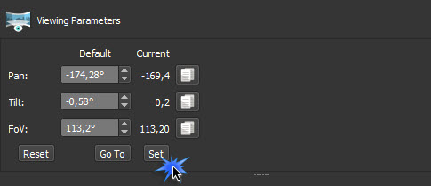
Viewing Parameters
try to click inside the preview window and press L on the keyboard and click Set
Viewing Parameters


-
360Texas

- Moderator
- Posts: 3684
- Joined: Sat Sep 09, 2006 6:06 pm
- Location: Fort Worth, Texas USA
- Contact:
Best I can tell,
Press and hold the "L" to bring level grid in the view box.
With the grid displayed use your mouse /pointer to drag:
the left view port AREA so the panoramas horizon moves to the grid horizon line.
the right view port AREA so the panoramas horizon moves to the grid horizon line.
IF you took your images hand held you probably need to Level each panorama individually.
Then you will see in the Viewing Parameters box that new level setting have been recorded. Click [SET] as shown in Svendus screen shot.
The Leveling DISPLAY settings are now a part of the Pano2vr project. Settings will be used to correct the projects viewing
I do not think it actually changes the original image horizon level if this Theta's image is used in another project or Theta's standalone viewing program.
PTGUI at Ptgui.com
To change the original image you probably can use PTgui's double Left and Right control points to level your fisheye horizon. This will re-characterize the Theta - image distortion.


-
Hopki

- Gnome
- Posts: 13025
- Joined: Thu Jan 10, 2008 3:16 pm
- Location: Layer de la Haye, Essex UK
- Contact:
Hi sirflor,
The Theta must contain the levelling data before Pano2VR can read it.
Make sure when your taking the pictures the LED near the shutter button is not red.
If it is wave the Theta around in a figure of eight motion until it turns Blue.
This means the data will be added to the images. If it is Red then it wont.
Regards,
Hopki
Garden Gnome Support
If you send an e-mail to support please send a link to the forum post for reference.
support@ggnome.com
https://ggnome.com/wiki/documentation/
If you send an e-mail to support please send a link to the forum post for reference.
support@ggnome.com
https://ggnome.com/wiki/documentation/
-
360Texas
- Moderator
- Posts: 3684
- Joined: Sat Sep 09, 2006 6:06 pm
- Location: Fort Worth, Texas USA
- Contact:
I think after the smartphone and Theta-S Wi-Fi are connected, the smartphone's GPS data is recorded in the Theta panorama's EXIF (meta-data) header block.
Using PhotoShop's FILE INFO, Theta's panorama contains Meta data shows Latitude, Longitude and elevation above mean sea level (MSL).
Then when that panorama is loaded in Pano2vr Pro, the GPS icon appears in the Tour thumbnail as usable information.
Taking NON WIFI Theta panoramas the GPS data is not recorded because the smart phone was not being used.
Backdoor settings for Samsung Galaxy S5 smart phones
I learned that GPS can be calibrated by:
Turning on the smartphone. Tap the telephone pad the characters *#0*# this will bring up a set of backdoor buttons - one of which "GPS STATUS and Tool Box". Lay the phone flat on table and Tap that button and it brings up a new screen where you can see GPS data searching for satellites and providing LAT/LONG and Altitude in meters. Press configure text line and the GPS will calibrate. Tap the "Pass" text button and it will lock in your current location reference for use later when you are out and about.
I found this by Googling "Calibrating GPS". I saw references to how to do this with other smartphones that have GPS.